 Несмотря на нынешнее, не совсем радужное, экономическое и политическое положение Греции в современном мире, ее вклад в развитие всего мирового сообщества недооценивать просто не нельзя и потому особенно обидно за страну, которая некогда была флагманом всей мировой цивилизации.
На страницах своего блога я много уже рассказывала о философах Древней Греции, о великих ораторах того времени, внесших свой вклад в развитие всей гуманитарной мысли.
Конечно, жалко немного тех студентов, которые боятся, что их "сведут с ума римляне и греки, сочинившие тома для библиотеки" (с), но без них, без их трудов и томов вполне вероятно, не было бы и русского алфавита, благодаря которому вы сейчас читаете эти строки.
Именно на греческой письменности основана кириллица – старославянская азбука, ставшая прародительницей русского алфавита.
Я не зря заговорила о кириллице. Сегодня, 24 мая, все страны славянской культуры отмечают день одноименной письменности, создателями которой были братья Кирилл и Мефодий. И жили они не где-нибудь, а в греческом городе Солуни.
По имени первого из них (не по времени рождения, а по месту перечисления в этой статье) – Кирилла, азбука и получил свое наименование – кириллица. От рождения, правда, имя этого человека было Константин. Кириллом он стал уже в сане иерея.
По одной из версий, создателем кириллицы был Кирилл, но и брат его Мефодий тоже не бездействовал, создав еще раньше - другую, более сложную, не основанную ни на одной из известных письменных систем, азбуку – глаголицу. Это была сложная система знаков, не нашедшая столь повсеместного, как кириллица, применения. Глаголицу вскоре вытеснила кириллица и как шрифт, которым были написаны богослужебные книги, глаголица сохранилась в Хорватии, где она использовалась до конца 18 века. Но не о ней речь, а ...
О кириллице
Как выглядели буквы кириллицы и чему они соответствуют в русском алфавите, можно проследить по этой таблице:
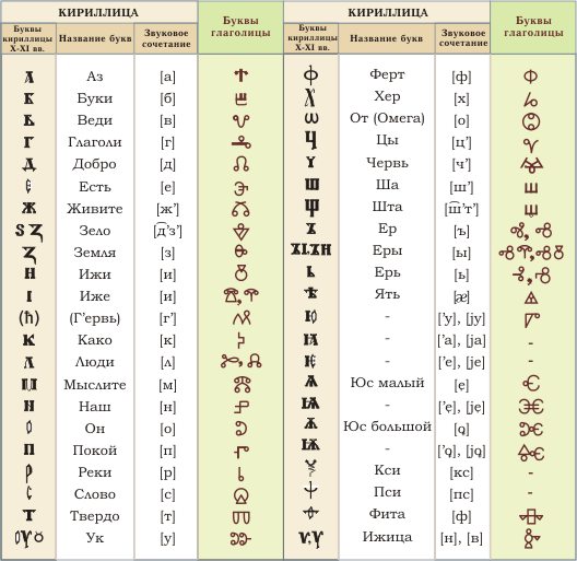
* Источник - pravoslavie.ru/smi/1971.htm
Свою существенную эволюцию кириллица в России претерпела в эпоху правления Петра 1, который исключил, к примеру, из нее омегу, пси и некоторые другие буквы, а также надстрочные знаки.
С этого времени светская литература стала набираться реформированной уже азбукой, а церковные книги – по-прежнему кириллицей.
Но и на этом развитие русского алфавита не остановилось. Так, в 1797 году Карамзин Н.М. придумал букву "Ё", от которой сейчас многие так упорно пытаются избавиться. Существует, правда, и другая версия (ну, а как же иначе), что букву "Ё" в обиход ввела княгиня Дашкова Е.Р., которая при обсуждении с литераторами учёными (Державиным, Фонвизиным и др.) первого проекта шеститомного толкового Словаря Академии Российской, спросила их почему, мол, слово «ёлка» пишется как «iолка». Не лучше ли две первых буквы заменить на одну? Возражений против этого не нашлось, а дело это было в 1783 году.
Свое же окончательное оформление алфавит, который мы видим сейчас и, главное пользуемся, получил в 1918 году, когда была проведена реформа, известная под названием орфографическая.
Конечно, люди обучались и обучались бы дальше и на древнегреческом языке и на латинском, но трудно представить себе, что было бы не придумай братья кириллицу. Хоть русский сам по себе и сложный язык, но роднее русского алфавита, кажется, ничего нет (во всяком случае для меня).
Но если у вас существуют сложности с изучением русского языка или, наоборот, вы чувствуете, что его необходимо подтянуть, на помощь придет... учебник русского языка. Да-да! Википедия не всесильна. Иногда надо в руки взять и обыкновенную книгу бумажного образца. А купить ее можно на сайте sotniknig.com.ua.
А вам какой ближе язык?
На этом пока все. До новых встреч на страницах блога http://rithelp.ru!


Интересная статья. Доступно о сложном написано.
С кириллицей не все так просто. Читала, что эти буквы содержали в себе целую ведическую филосфию. И , когда их убрали, из памяти людской стали стираться важные понятия.
@Viktoria Zlata, Ой, абсолютно согласна! Разобраться в этих буквах, символах, значениях- надо быть ученым, который посвятил этому вопросу не один десяток лет.
@Viktoria Zlata, что за ведическая философия? Ну о чем Вы??? Найдите сходмство между письмом деванагари и кириллицей. Ну пожалуйста!!! Хоть одно сходство!!!
Кристин, ей-Богу, накатаю целую статью про "ведическую философию" и что это на самом деле. Что за бредни, извини за мою резкость, овладели умами людей? Ну почему никто не читает серьезную исследовательскую литературу, труды археологов и историков, но все свято верят каким-то сомнительным басням про Гиперборею и иже с ней???
Люди, вы читали Веды??? Ригведу, Самаведу, Яджурведу, Атхарваведу??? Вы знаете, что такое индоевропейцы, арии, ностратики???
Откуда все эти басни??? Уязвленное национальное самолюбие?
Кристина, кстати, вы знаете,что у вас кнопки соц.закладок исчезли?
@Viktoria Zlata, Нет, Виктория Злата, я без понятия. У меня все нормально показывает.... Как это исчезли? Ни одной кнопки что ли нет?
Надо же... У меня тоже разные аномалии на блоге бывают
Я это еще некоторое время назад заметила. Думала, что вы в курсе, просто времени пока нет этим заняться.
У меня лично это выглядит так:"Спасибо за добавление статьи в:"
и дальше внизу уже только реклама висит. Кнопок нет. Может, конечно, это от браузера зависит, незнаю. Я через Оперу захожу.
У меня тоже на рекламе тогда кракозябры были, а смотрела со своего компа-все в порядке, пока мне один добрый человек не написала. Спросила в поддержке, точно кракозябры.
@Viktoria Zlata, Нет, на твоем блоге я никаких кракозябров не вижу - все кнопочки в порядке. Да, это наверное от браузера зависит. У мужа IE и там да, я видела полосочки одни, на других компах я смотрела, в основном через Мозиллу - все в порядке.
До чего же надоели все эти недоработки, ошибки, зависания =) Никаких условий для творческой деятельности)))
Вверху кнопка от Гугла исправно стоит.
@Viktoria Zlata, И на том спасибо )))
Кристина,зашла через Мазиллу, тоже самое с кнопочками. Может быть, написать в поддержку хостинга?
Пусть они глянут, если что? Конечно, вам виднее, мое дело только преджолить, как говорится
@Viktoria Zlata, Виктория Злата, спасибо, что предупредила! А то я думала, что это у мужа на компе глюк какой-то =(
Через Мозиллу и Гугл хром зашла - всё в порядке с кнопками.
Тоже слышала, что не просто так буквы назывались словами: "добро", "покой, "реки"... Алфавит был значительно больше и был своеобразной молитвой, памяткой о том, как нужно правильно жить. И поэтому учили алфавиту детей.
Да, не удивительно, что именно при Петре I были введены значительные изменения в кириллице) Вообще, конечно, язык и письменность меняются постоянно) И мне великий могучий русский ближе всех, тем более, что я другие и не знаю)))
Нам очень многое досталось от греческой культуры, начиная с письменности и кончая вероисповеданием. Поэтому чувствую к грекам, как к нации, почти братские, родственные чувства, как и ко всем славянам.
много от Греции знаний взято. В те времена когда она прцветала
«Наш народ крещен, а учителей у нас так и нет. Мы не понимаем ни греческий, ни латынь... У нас нет письменности, и мы не понимаем смысла написанного; поэтому пошлите нам учителей, которые могли бы научить нас читать и понимать Писание» (Ростислав, моравский князь, 862 год).
Среди лингвистов ведется много споров по поводу того, какую азбуку создал Кирилл. Азбука, названная кириллицей, практически полностью основана на греческом алфавите с добавлением дюжины дополнительных знаков, представляющих славянские звуки, отсутствующие в греческом языке. Однако в некоторых древних славянских рукописях используется совсем другая азбука, известная как глаголица, и многие исследователи полагают, что именно эту азбуку изобрел Кирилл. Некоторые буквы глаголицы, вероятно, произошли от скорописных греческих или еврейских букв. Некоторые, возможно,— от средневековых диакритических знаков, но в целом азбука — это новоразработанная, сложная система. Глаголица — произведение более яркое и самобытное, нежели кириллица, однако алфавиты современных языков: русского, украинского, сербского, болгарского, македонского и еще 22 других языков (некоторые из которых не славянские) — произошли не от глаголицы, а от кириллицы.
Мария Анашина -не сердитесь, уважаемая.
Ни в коем мере не предентую на звание знатока в данной тем. Прекрасно сознаю, что лишь поверхностно с этой информацией соприкасаюсь.
Просто читала статью в журнале одном, там про это писалось.
Я лишь высказала свое мнение, вполне возможно, оно и ошибочным является.
"Ну почему никто не читает серьезную исследовательскую литературу, труды археологов и историков, но все свято верят каким-то сомнительным басням про Гиперборею и иже с ней???"
1- к чему такие обобщения?Как это НИКТО НЕ ЧИТАЕТ? Вы же читаете, видимо, значит и еще кто-то читает.
2-почему вы решили, что все ПОГОЛОВНО обязаны это читать?У каждого свой путь и свои интересы. Каждый интересуется тем, к чему его душа лежит.
Вы соционику читаете, например? А я читаю.
На мой взгляд, хорошо, что люди вообще хоть немного стараются разобраться в такой большой и серьезной теме.
Эти труды, чтобы читать, их нужно иметь под рукой, не так-то все просто.
3- с чего такая странная категоричность? С чего вы взяли, что ВСЕ СВЯТО верят? Почему вы опять страдаете обощениями? Кто-то верит, кто-то нет, а третьим вообще на все это наплевать...Им бы водку, да селедку 🙂
4- с удовольствием почитала бы Веды. Покупать все эти книги возможности пока не позволяют.
Хорошо, что хоть вы читаете и владеете в данной сфере большими познаниями. Значит, светоч знаний не пропадет в пустую и это отлично.
5 откуда басни? Думаю, это вопрос не нам, современникам нужно адресовывать. Корни глубже находятся.
Пожалуй, данный вопрос можно переадресовать вам. Вы же здесь претендуете на звание специалиста.
@Viktoria Zlata, я уже написала, что резка в этом вопросе. И еще раз прошу извинить меня за мою категоричность. Но когда масса блоггеров и вообще пишущих людей начинают с видом знатоков рассуждать о ведической культуре, основываясь на сомнительных источниках, поневоле становится не по себе.
Знаете, что дает высшее образование? Умение разбираться в источниках. Вот Вы пишите: "Просто читала статью в журнале одном, там про это писалось". Что за статья? Что за журнал? Кто автор этого сочинения? На каких источниках он основывается?
К сожалению, я не знаю, кто Вы по специальности. Но думаю, что в своей области Вы можете отличить правду от вымысла. И если кто-то напишет явный бред, Вы молниеносно среагируете.
Думаю, и в других сферах Вы не будете доверять сомнительным источникам. Вряд ли Вы ограничетесь одним источником, когда будете изучать какую-то проблему, важную для себя.
Согласитесь, Вы же не знаете, что такое Веды, ведическая культура. Так зачем же Вы об этом пишите??? Путь даже и в комментарии?
Я никоим образом не претендую на звание специалиста. Да и вряд ли кто-то из моих коллег-востоковедов осмелится назвать себя "специалистом".
Извиняетесь за категоричность и тут же опять резко высказываетесь
Ну, да ладно...
Сделаем скидку на виртуальный формат общения.
Наверняка в "живую" с вами очень интересно и приятно общаться. Здорово, что есть думающие люди на этом белом свете, к тому же на такие важные вопросы.
Не вижу смысла продолжать с вами спор...
Много чего ответить можно было...Мне неприятно вести переписку в таком тоне.
Успехов.
@Viktoria Zlata, не хотела Вас обидеть. Прошу извинить меня.
Вот и славно.
Мне тоже бывает досадно. Например, пришла в магазин и в разговоре со мной продавец говорит фразу и ссылается на Библию, а я точно знаю, что там такой цитаты нет. Я ей с улыбкой говорю, что такого там нет. Хорошо, что хоть не стала настаивать.
Человек, который разбирается в какой-то теме хорошо, словно зрячий. А невежественный в данной сфере, как слепец.
Да уж, невежество - корень многих наших бед.
Просто темы, которые вы затронули в переписке, мне действительно интересны.
Если мне встречается на пути книга на эту тему, с громадным удовольствием ее читаю.
Например, сейчас мне нравится читать книгу "Великие Посвященные" Эдуарда Шюре 1914 г.
Такие дебаты у вас на блоге, Кристина, зачиталась комментариями. Я вот тоже однажды задалась целью разобраться, откуда произошла наша письменность, но заблудилась в дебрях различных мнений и источников.
@Людмила, Да, Люда, я тоже зачиталась, не смея встрять. Сама я недостаточно сильна в этом вопросе, да и спор красивый получился (если можно так сказать) между двумя грамотными женщинами - одно удовольствие читать =) Глядишь, и я для себя почерпну новой информации =)
Кристина, Людмила, спасибо за комплемент и еще раз извините за резкость. Но честно, я уже зверею, когда встречаю рассуждения о ведической философии и культуре. Сейчас появилось очень много сомнительной литературы, которая ставит все с ног на голову. Такое ощущение, что не было почти двух столетий сравнительного языкознания, индоевропеистики. Больно становится от того, что сейчас какие-то странные теории выдаются за истину в последней инстанции, а выверенные и согласующиеся с данными огромного количество наук объявляются ошибочными.
У себя на блоге я даже написала пост по этому поводу.
@Мария Анашина, А сейчас со всем так - все пересматривается, все меняется, все переворачивается с ног на голову. Если кто-то сможет убедить других в правоте своей теории, пускай и насильно, та философия и станет доминирующей на определенном участке исторического времени. И поди разберись со всем этим. Столько школ, столько направлений - и каждый выбирает и защищает то, что ближе ему.
@Кристина, Кристин, не путай философию и идеологию. Идеология - да, меняется в угоду правящему режиму. Наука же и философия, если ученый действительно занят поиском истины, а не теплого места, вне идеологии. Даже в советские годы ученые-гуманитарии (а по ним идеология била больнее всего) умудрялись работать и открывать потрясающие вещи.
Да, мы не обладаем всей полнотой фактов. Но, по крайней мере, я знаю, что теория тогда считается истинной, когда она согласуется с различными фактами из разных областей знания, проверяется и перепроверяется.
@Мария Анашина, Нисколько не сомневаюсь в серьезном подходе ученых, в том, что они факты проверяют и перепроверяют.
Только вот вопрос у меня - данные, из которых складываются факты, со временем претерпевают изменения. Там подтвердилось, там нет, там появились новые факты, ранее неизвестные и т.п. - и вот ученые признают свои предыдущие выводы ошибочными или же все-таки пытаются найти дополнительную информацию, чтобы только подтвердить уже укоренившееся мнение?
@Кристина, ой, как все запущено... Прочитай замечательную книгу Томаса Куна "Структура научных революций" и Имре Лакатоса "Методология научных исследований". Это - программные, так сказать сочинения.
Конечно же от многих прежних выводов наука отказывается. Но прежде чем принять новые - факты проверяются и перепроверяются. Например, в геологии долгое время существовала теория фиксизма, согласно которой земная кора претерпевает только вертикальные колебания. Однако постепенно накапливались факты, противоречащие этой теории. И сейчас принята теория литосферных плит (геологи скажут точнее), основы которой заложил Вегенер.
Другой пример - Ньютоновская механика. Когда-то незыблемым считался принцип сложения скоростей. Он действительно работал в нашем мире. Но он оказался неверным для больших скоростей (приближающихся к скорости света). Появилась теория Эйнштейна. И сейчас четко обозначены границы применимости ньютоновской механики.
Равно как и с теорией Эйнштейна - сейчас накапливаются факты, которые не вписываются в эту теорию. Скорее всего, просто будут обозначены границы применимости эйнштейновской физики, потому что многие вещи прекрасно работают в рамках этой теории.
Научная теория отличается от ненаучной тем, что первая имеет границы применения. Научная теория не претендует, чтобы объяснять все.
Есть классическая схема научной теории (попробую ее изобразить)
Теоретический закон
Эмпирический закон 1 Эмпирический закон 2
Факт 1 Факт 2 Факт 3 Факт 4 и т.д.
Итак: на основе фактов выводятся эмпирические законы. Далее строится гипотеза, на основе которой выдвигается теоретический закон. Если из теории можно вывести имеющиеся уже эмпирические законы и факты, она верна. Если же гипотеза не может объяснить имеющиеся факты и эмпирические законы и из нее нельзя вывести новые, которые в свою очередь проверяются эмпирическим путем, она не верна.
Это очень упрощенная схема. Но в целом она работает (опять-таки, это самые основы эпистемологии, профессионалы в этой области скажут точнее).
И вообще это очень упрощенный подход: "ученые". Никогда наука не представлена монолитным собранием "ученых". Есть школы, сообщества, исследовательские группы. Но главное, что есть в науке - выводы одних исследователей могут быть проверены и подтверждены выводами других исследователей.
Наука - это постоянное обсуждение, проверка. Наука немыслима без диспута. Именно для этого и происходят защиты диссертаций. Я прошла через это, неоднократно сама присутствовала на диссертациях, выступала в роли оппонента и рецензента. Недаром говорят - "защита". Ты защищаешь свои выводы, аргументированно доказываешь, почему ты прав. Тебе задают разные вопросы, на которые ты отвечаешь. Бывают здесь профанации? Да, бывают. Как и везде. Но время все расставляет на свои места.
@Мария Анашина, Процесс создания научной теории мне понятен. Хотя, как пишешь это ты, хочется читать и читать. Вопрос в другом - когда рушится эта научная теория... Боюсь, что даже факты, не говоря уже об эмпирических законах, многими воспринимаются не однозначно. Тяжело отказываться от того, доказательству чего ты посвятил всю свою жизнь.
@Кристина, Кун описывает процесс смены парадигмы очень красноречиво: инфаркты, уход старшего поколения...
На самом деле, именно поэтому в науке и предусмотрены разные формы обсуждения: защиты, рецензирование, конференции. Когда специалисты в твоей области могут проверить и перепроверить твои результаты.
Обрати внимание: как раз именно псевдоученые не стремятся общаться со специалистами. Они выпускают книги большими тиражами, властвуют над умами дилетантов в данной области. Но общаться со специалистами - ни-ни.
Я выросла в семье ученых - уже четыре поколения в моей семье посвящают себя науке. И я знаю, что и я, и мои родичи, и мои коллеги - мы заинтересованы в обсуждении. Например, оппонентом на моей защите кандидатской был известный буддолог В.П.Андросов. Он задавал мне "неудобные" вопросы, он указал мне на мои неточности. Где-то было уязвлено мое самолюбие. Но я очень благодарна ему за все эти замечания, потому что он открыл мне глаза на многое, помог увидеть проблему под другим углом. С другой стороны, с некоторыми его замечаниями я не согласилась и смогла это аргументировать. Это и есть защита.
@Мария Анашина, Общение, обсуждение очень важны! Именно в беседах рождается самое интересное (хотела написать истина, но передумала). Именно этот формат: вопросы и ответы, вопросы и ответы.
Маша, а ты действительно дева-воин! Боевая личность!
@Maria Trudler, Машунь, спасибо за комплимент 🙂
Я поняла, насколько важен диспут, когда соприкоснулась с восточной философией. В Индии издревле существовала культура диспута, что, в свою очередь, стимулировало развитие философии, логики, практики аргументации и др. В Китае этого было меньше, поэтому и уровень иной. Известный китайский буддист 7 в. Сюаньцзан, оказавшись в Индии, отмечал это - что благодаря диспутам индийская философия очень утонченная и аргументированная, в отличие от китайской.
В Греции тоже существовала культура диспута. Да, истина в споре не рождается - ее вообще невозможно родить. Но обсуждая, аргументируя, сталкиваясь с другой точкой зрения, ты сам начинаешь лучше разбираться в своей собственной проблеме, проговариваешь то, что вроде тебе кажется очевидным, находишь свои слабые места.
@Мария Анашина, Да, истина - расплывчатая категория. Боюсь, ее нет вообще. Можно придти к единому знаменателю в обсуждении, но не факт, что это истина, тем более, что она сама не обладает точной формулировкой
@Мария Анашина, ой, Маш, мой комментарий тебе ушел вниз почему-то, видно не то нажала...
Кристин, аристотелевское определение истины в общем работает: "Истина - это соответствие наших суждений реальности". И прагматисткое определение тоже работает: "Практика - критерий истины" (первыми этот постулат выдвинули китайцы).
На востоке есть еще учение о двух типах истины: относительной и абсолютной. Относительная выражается в словах и может быть передана от одного человека к другому, абсолютная - вне слов, постигается индивидуально и интуитивно. Эти две истины взаимосвязаны, в санскрите словосочетание "две истины" употребляется двойственное число (исчезнувшее в других индоевропейских языках). Но абсолютная истина все-таки относится к области трансцендентного.
А возвращаясь к нашим пирогам... Если какое-то утверждение (например, историческая теория) находит подтверждение в других дисциплинах, если его можно проверить, значит, оно истинно. То, что Земля круглая (ну ладно, геоид, кардеоид - это уже уточнения) - это истина. То, что Волга впадает в Каспийское море - это тоже истина. То, что санскрит относится к индоевропейским языкам и существует индоевропейская языковая семья - это тоже истина.
Здесь можно, конечно, поставить под сомнение слово "реальность" - способен ли вообще человек познать реальность, или он только ограничивается познанием явления, обусловленного нашими познавательными способностями (чувственным и рациональным). Но по крайней мере, если переформулировать Аристотеля, можно сказать, что истина - это соответствие наших слов реальности, явленной нам в опыте.
@Мария Анашина, Да, С Аристотелем трудно спорить, но согласна, что и понятие реальности - оно у всех разное. Взять тех же самых дальтоников, к примеру.
Или сегодня река Волга - впадает в Каспийское море, а назавтра ее переименовали (условно говоря) и истина уже не та. Гераклит тоже был прав, утверждая, что все течет и меняется.
Что-то я не понимаю слово "трансцендентность" ? ...Это из области необъяснимого?
Очень интересная статья. Особенно мне понравилось сравнивать символы кириллицы с современным написанием букв. Да и названия букв сами по себе имеют философский смысл.
Я мало что смыслю в вещах, о которых здесь отписались остальные гости Вашего блога.
Выскажусь просто как дилетант. Я ничего против не имею, что азбука со временем претерпела преобразования. Ведь цель была какой? Упростить изучение народом грамоты. Те, кто упрощал, сами прошли через все эти образовательные коллизии, сами.наверное. в детстве намучились. Если мы совершенно счастливо обходимся без этих букв, которые убрали, значит, можно и так, без них.
@Михаил, Мы, в большинстве своем, здесь все дилетанты общаемся. Чтобы разобраться в тонкостях исторического развития надо быть специалистом в этой области. Но это совсем не значит, что у нас нет собственного мнения и представления. Мы будем говорить, а специалисты нас поправлять. Ведь если не будем произносить вслух, то никто не узнает и не поправит нас в том, что мы думаем неправильно.
Я не против упрощения, но не кажется ли Вам, что это привело, в конечном итоге, к тому, что грамоты совсем не стало?
Хи. Ну, конечно, мне русский всего ближе. Я других языков, собственно, и не знаю - во всяком случае хорошо. Впрочем, иногда мне кажется, что и русский я не так уж хорошо знаю. ))
@ladybloger, Хорошо сказала Я также думаю. Но, не зная других языков (во всяком случае, так хорошо, как русский), мне тем не менее очень нравится, как звучит шведский и итальянский языки.
А один раз был случай, прожив в Литве дней 10 и слыша кругом только литовскую речь (язык которой мне не нравится ) - когда я села в наш латвийский автобус, я чуть не расплакалась от радости, что слышу родной (так я тогда посчитала) латышский язык. Слушая речь стюардессы, я была уверена, что латышский я знаю, лучше, чем русский)))
@Кристина, латышский - красивый язык. Я его часто раньше слышала. Не знаю, доведётся ли ещё.
@ladybloger, Да! И уж тем более красивее литовского и эстонского )))
Здорово! Респект и уважуха!
@Viktoria Zlata, Viktoria Zlata, а это к чему?
@Кристина, я думаю, это к Галиным словам относится
@Елена, не угадала
О, не за что! В моем представлении, ты рисуешься древней богиней, сидящей на кургане и созерцающей свое несметное войско. ))
Примечательно, что диспуты, беседы стимулируют не только развитие науки, но и искусства! (Каждый о своем, любимом) Ведь во времена, когда художники активно дружили, встречались, общались, спорили о смысле искусства и о прочих тонкостях, рождались самые яркие художественные течения! К ним присоединялись поэты, писатели, философы и от этого результат бы еще более упоительным.
Маш, а как чисто внешне проходили в древности диспуты в Индии? Это были специальные собрания или встречи? Где они проходили, на что были похожи?
@Maria Trudler, Маша, можно я внесу небольшую коррективу с учетом собственного видения?
Не сидящей на кургане, а гордо восседающей на своем коне =)
@Кристина, Вот-вот, я тоже в начале именно так и написала - восседающей на коне, потом - сидящей на кургане - и запуталась совсем. Кристина, именно на коне мне Маша рисуется. Она так гордо сидит на своем Кубике - залюбуешься. ))
@Maria Trudler, Кристина, право, мне даже неловко...
@Мария Анашина, Да ладно, Маша, надо внести и шутливую нотку в разговор =) В которой есть доля правды)))
@Maria Trudler, ))) Поболтать народ всегда любил - в любой стране и при любой формации )))
Кристина: мои слова относятся к этому:Мария Анашина
"Я выросла в семье ученых — уже четыре поколения в моей семье посвящают себя науке.
И я знаю, что и я, и мои родичи, и мои коллеги — мы заинтересованы в обсуждении.
Например, оппонентом на моей защите кандидатской был известный буддолог В.П.Андросов. Он задавал мне «неудобные» вопросы, он указал мне на мои неточности. Где-то было уязвлено мое самолюбие. Но я очень благодарна ему за все эти замечания, потому что он открыл мне глаза на многое, помог увидеть проблему под другим углом. С другой стороны, с некоторыми его замечаниями я не согласилась и смогла это аргументировать. Это и есть защита.
"
Моя реакция на эти слова: "Здорово! Респект и уважуха!"
@Viktoria Zlata, Согласна, Viktoria Zlata, это достойно уважения!
Кристина, и статья интересная, и дебаты! Мне кажется так выразить свои чувства и эмоции, как с помощью великого русского языка, невозможно на любом другом.
@Елена, прошу прощения, что отвечаю, но уж очень интересная дискуссия.
Русский язык - оно, конечно, красивый. Но сколько смыслов, тонкостей в английском, французском, санскрите. И то-то ни один китаист не может адекватно перевести с китайского тот же Дао-дэ-цзин - нет в русском таких слов, как в китайском, нет таких смыслов. Каждый язык - свое семантическое поле, своя картина мира, свой неповторимый образ реальности.
В том же санскрите есть двойственное число - вот как в русском языке грамматически выразить неразделимое единство двоицы? Никак!
@Елена, Может все дело в том, что мы других языков не знаем? Почитала комментарий Маши и пересмотрела отношение к китайскому языку. Другой вопрос, что нам это не близко по духу - зачем нам, обывателям, такое понятие, как "неразделимое единство двоицы" ....
«Никакая история не даст нам более полного представления обо всех перипетиях жизни народа, о его социальном устройстве, о его верованиях и чувствах, чем его язык» (Мартин Алонсо).
@Ольга Агапова, Ну да, без языка сложновато понять друг друга =)
Происхождения языков, их многообразие и динамика до сих пор вызывают неослабный интерес ученых. Даже сами плоды их исследований — как и большинство исторических документов — сохраняются именно благодаря языку. Бесспорно, язык — основное средство человеческого общения.
Сегодня, по оценкам некоторых лингвистов, в мире существует около 6 000 языков, не считая диалектов. Больше всего людей — свыше 800 миллионов человек — говорит на китайском языке. Следующие четыре из самых распространенных языков — английский, испанский, хинди и бенгальский.
Что происходит, когда разные культуры, а значит и языки, неожиданно начинают взаимодействовать друг с другом? И наоборот, как обособленность той или иной группы людей влияет на их язык?
@Ольга Агапова, Ольга, и что происходит, когда разные культуры, а значит и языки, неожиданно начинают взаимодействовать друг с другом?
@Ольга Агапова, Поспешила спросить, не прочитав второй комментарий =)
@Кристина,
Не боишься санкций поисковиков за дублирующийся контент? Ольга старательно скопировала статью с одного сайта, могу дать ссылочку.
@Мария Анашина, Да, я уже видела. Но она сама там автор этой статьи, я так понимаю. Да и комментарии вроде как не должны индексироваться...Или я не права? Во всяком случае я ставила такое правило в роботексе...
@Кристина, у меня на китайском блоге она повторяла статью Вяткина. В любом случае, это твой блог, тебе самой виднее, какие комментарии пропускать.
В процессе колонизации, торговли между странами и даже во время заключения в концентрационном лагере людям обычно приходится преодолевать языковой барьер. Поэтому они прибегают к упрощенному языку. Они отказываются от сложных грамматических форм и конструкций, пользуются меньшим количеством слов, ограничиваясь лишь теми, которые относятся к интересующей их области. Таким образом возникли пи́джины. Пиджин — это язык, упрощенный до предела, который имеет свою лингвистическую структуру. Но как только отпадает потребность в нем,— потребность, благодаря которой он и возник,— этот язык может исчезнуть.
Если пиджин становится основным языком населения, к нему добавляются новые слова, его грамматика преобразовывается. Он превращается в креольский язык. Креольские языки, в противоположность пиджинам, отражают особенности той или иной культуры. Сегодня в мире существует множество пиджинов и креольских языков, возникших на лексической основе английского, португальского, французского языков, суахили и других. Некоторые даже стали основными языками страны, например ток-писин в Папуа-Новой Гвинее и бислама в Вануату.
Еще одним средством общения являются общепонятные языки — лингва франка. Ими пользуются те, у кого родные языки разные. В Центральноафриканской Республике, например, носители различных местных языков могут общаться с помощью санго. В дипломатических кругах в качестве лингва франка используются английский и французский языки. В роли лингва франка может выступать и креольский язык, и пиджин.
В отдельных областях той или иной страны иногда пользуются местными разновидностями национального языка, или диалектами. Чем изолированнее область, тем ярче выражены отличительные особенности данного диалекта. Со временем некоторые диалекты настолько теряют сходство с исходным языком, что превращаются в самостоятельные языки. Бывают случаи, когда лингвистам трудно провести границу между языком и диалектом. Кроме того, языки постоянно развиваются, и потому, постепенно выходя из употребления, диалекты иногда исчезают, а вместе с ними исчезает и частица истории.
Поскольку человек — существо общественное, это находит отражение и в языке. Когда различные культуры взаимодействуют — а это весьма распространенное явление,— отголоски взаимного влияния заметны на протяжении целого ряда поколений.
Например, в испанском языке, который считается разновидностью латинского, много слов арабского происхождения — свидетельство того, что в VIII веке территория Испании была захвачена арабами. Также можно заметить, что на испанский язык оказали влияние греческий, французский, английский и другие языки. Кроме того, испанский, на котором говорят в Америке, сохранил некоторые черты языка древних коренных жителей этого континента: многие слова пришли в испанский из науатля — языка ацтеков Центральной Америки.
Зная, какой язык для человека родной, можно узнать, из какой он страны и даже из какого региона. А по его лексикону можно определить, к какой группе людей он принадлежит, то есть какие у него, к примеру, профессия и род занятий, к какой области культуры или виду спорта он имеет отношение или даже то, что он принадлежит к преступному миру. Этот перечень можно продолжать практически бесконечно. Специфический язык, свойственный определенной группе людей, лингвисты называют жаргоном, сленгом, или арго.
Когда между странами, этническими или социальными группами существует вражда, язык престает быть связующим звеном. Он может стать барьером, который лишь еще больше разделяет людей.
Общение — сложное явление. Сегодня люди стремятся преодолевать языковые барьеры, и особенно большую роль в этом играют средства массовой коммуникации. Как отмечается в «Британской энциклопедии», сейчас английский язык является основным или вторым языком каждого седьмого жителя земли. Таким образом, он чаще, чем любой другой язык в мире, выступает в роли лингва франка. Он помогает людям расширить сферу общения и облегчает обмен полезной информацией.
В то же время языковые барьеры усугубляют разобщенность, ненависть, способствуют войнам.
@Ольга Агапова, Да, язык - сложная субстанция. Без него никак, но в то же время он может стать не только связующим звеном между людьми, но и прекрасным оружием для его разобщения. Ситуация в Прибалтике - наглядный тому пример, когда политическая власть ловко манипулирует межэтническими конфликтами, способствуя не сплочению общества, а наоборот его разъединению =(
Да, значит в каждом своя философия!
Трансцендентность - буквально "по ту сторону", то, что не доступно опыту, чувствуенному познанию. Например, Бог.
С понятием реальности у дальтоников - немного не так. Дальтонизм или слепота, к примеру - это отклонение от нормы. Большинство людей все-таки видят реальность примерно одинаково. Но реальность человека будет, по-видимому, отличаться от той реальности, которую видит кошка. Или муравей, к примеру.
С Волгой и Каспийским морем - это все-равно истина, как бы ни называлась Волга и Коспийское море. Другое дело, если Волга поменяет русло, Каспийское море пересохнет и т.п. Но опять-таки, для данного момента времени (пока есть река Волга и Каспийское море, не важно, как их называют) утверждение, что "Волга впадает в Каспийское море" является истинным.
Если бы не было таких истин, человек не мог бы ориентироваться в реальности. Вернее, в той реальности, которая дана ему в опыте (Кант). Какая реальность на самом деле - это недоступно нашему пониманию (см. Кантовское разделение на "явление" и "вещь-в-себе").
Но есть вещи, которые на данный момент времени являются истинными. Мы же не станем спорить, что тебя зовут Кристина, а меня - Мария и в данной теме мы обсуждаем, помимо всего прочего, проблемы истины 🙂
@Мария Анашина, Нет, ну конечно, Маша, реальность должна существовать. Можно ответвлять рассуждение до бесконечности, вплоть до имен - по типу, когда крестили - дали другое имя. Хотя бы на определенном отрезке времени должно быть что-то общее. Так что, пока Каспий не пересох, будем считать истиной то, что Волга в него впадет =)
Статья сама по себе великолепна, но какой чудесный диалог вокруг нее организовался, это просто очень здорово! С удовольствием почитал дискуссию вокруг Вед и концепцию научных теорий.
@Александр, Очень приятно, что Вам понравилось. Иногда, да, комментарии более ценные, чем сама статья, особенно если дополнены компетентными в вопросе лицами
Кристина, спасибо огромное за таблицу. Я ее себе взяла.
@Надежда, Пожалуйста, Надя! А для чего она нужна, если не секрет?
Ничего не принимайте близко к сердцу. Немногое на свете долго бывает важным.
© 2026. Жизнь и философия
Все статьи на блоге "Жизнь и философия" авторские. При перепечатке любых материалов с сайта активная ссылка на rithelp.ru обязательна.